Detail Itinerary:
Day 01: Arrival in Kathmandu [1,330m]: Upon your arrival, a representative from Adventure Treks Nepal will be waiting outside the airport gates to take you to the hotel. Depending on time of arrival, plans will be made for a briefing meeting once you have settled in. Please let us know if there is anything special you would like to do while in Kathmandu and we can help you arrange that. Overnight stay at Hotel.
Day 02: Cultural Tour in Kathmandu [1,330 m] - (B):After Breakfast we Proceed for sightseeing tour of Bhaktapur city 15 km from Kathmandu, known as city of Devotees and center of medieval art and architecture founded by King Anand Dev in 889 AD, visit Nyatpola temple, the most beautiful temple of Nepal, the 15th century palace of 55 windows, Golden gate and other place of Interest. Lunch Time: 1300hrs-14:00hrs PM: Visit Pashupatinath temple one of the most sacred Hindu shrine in the World. The holy river Bagmati and the burning ghats and also visit one of the oldest and biggest stupa of Boudhanath. Overnight stay at Hotel.
Day 03: Drive to Benshishar [820m] After Lunch drive to Chamje [1,430m] - (B,L,D): After breakfast at Hotel in Kathmandu we drive along the Kathmandu-Pokhara Highway to Dumre and then follow the rough road by the Marsyangdi River to Besi Sahar. [drive approx 6 hours]. Besi Sahar is the starting point of the trek (In the past). After lunch we drive to Ngadi where we spend Night. Overnight stay at Tea House.
Day 04: Trek to Bagarchap [2,160m] - (B,L,D): Crossing the east bank of the Marsyangdi we follow the trail along the river embankment on rocks. Passing under an overhanging rock, we climb a rocky trail and a steep stone staircase to several tea shops in Sattale, then make a short to descend to Tal Besi and then head for Khorte and then to Karte. We climb from the bridge to a stone kani marking our entrance to Dharapani. Beyond Dharapani, we pass through a school and climb over a spur. 30 minutes walk through a forest of blue pine, spruce, hemlock, maple and oak will reach us to Bagarchhap. Overnight stay at Tea House.
Day 05: Trek to Chame [2,630m] - (B,L,D): Staying on the south bank of the river we climb through forests to Danaque. Beyond Danaque the route crosses a stream on a wooden bridge, and then reaches a trail junction, we follow the usual route to Manag, which is the right fork. A broad level stretch of trail will lead us through forests to a cement bridge near a spectacular waterfall. We traverse a rock ledge, climb over a ridge on a steep, rocky trail and descend to the tiny settlement of Temang Besi. We cross several landslides as it works its way uphill through a forest of walnut trees to Lattemarang. After making several ups and downs over forested ridges and landslides, crossing a large stream and the ridge we reach to the entrance chorten of Kotha, known as Kyupar from where we can look straight up at nearby Annapurna II - a sight convincing us that we are deep in the Himalayan mountains. From here climbing through a fir and pine forest we reach to Chame, the administrative headquarters for the Manag District. Overnight stay at Tea House.
Day 06: Trek to Pisang [3,230m] - (B,L,D): After breakfast at Chame, we set off for Pisang. We continue making a long and pleasant walk in the forests, crossing a short landslide, to a huge apple orchard surrounded by a stone wall. From this point the valley becomes extremely steep-sided as we follow the path to Bratang. There is also a bridge leading us to the old part of Bhratang, which used to be a Khampa settlement. We without crossing the bridge , staying on the northern side of the river follow a new trail that has been blasted out of the side of the cliff. We cross to the south bank of Marsyangdi on a suspension bridge. Further ups and downs from here will lead us to Pisang. Overnight stay at Tea House.
Day 07: Trek to Mananag [3,540m] - (B,L,D): Continue being at the Southern side of Marshyangdi, we cross a stream and make a long climb over a forested ridge that extends across the valley. A short descend will lead us to the broad valley floor. We follow along the valley floor to Manang’s airstrip at Hongde. We further pass a long mani wall and then the airport, thirty minutes beyond the airport there is Sabje Valley, with Annapurna III and IV just above. We cross to the north bank of the Marshyangdi on a wooden bridge near mungji and then climb past fields of barley and buckwheat over a low ridge at Bryaga. A short walk past chorten and mani walls, will lead us to the Plateau of Manang. Overnight stay at Tea House.
Day 08: Rest day at Manang [3,540m] - (B,L,D): We spend one whole day at Manang taking rest which is very important for us before crossing the Thorung La. We can spend the rest day by making visits to various places. We can climb high above the village for a full panorama of the Annapurna range and the Manang Valley. There is also a Himalayan Rescue Association [HRA] aid post in the village, which makes an interesting and educational visit. We can also walk to visit the Bhojo Gompa. Overnight stay at Tea House.
Day 09: Trek to Letdar [4,250m] - (B,L,D): From Manang, we cross a stream and climb to Tengi, which has the magnificent Annapurna Himal views to offer all the way. From here the trail climbs to a small village of Gunsang at 3960m. We pass through sparse forests of Juniper, rose and barberry and cross a large stream, then pass an ancient mani wall in a meadow at 3990m. Beyond is Yak Kharka , also known as Koche. An hour walk further from Yak Kharka is Letdar. Overnight stay at Tea House.
Day 10: Trek to Throng Phedi [4,500m] - (B,L,D): After an early breakfast at yak kharka we continue with our trek for the day. From Yak kharka gradual climib to Letdar then the trail continues to climb along the east bank of the Jarsang Khola, then descends and crosses a stream on a wooden bridge at 4,310m. We make a short ascent on a good trail to a tea shop, then we follow a narrow trail across a high, unstable scree slope and then descend to Thorung Phedi. O/n in Lodge. Overnight stay at Tea House.
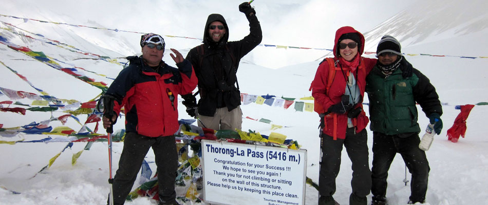
Day 11: Trek to Muktinath [3,802m] - (B,L,D): people for hundreds of years the path, though often steep is well defined and easy to follow. It will take us almost 4 hours from Thorung Phedi to reach to the pass. The views from the trail and from the pass itself, are outstanding high Himalayan scenes. We then start descending down the barren Kali Gandaki Valley, which is far below the to the west. The descent is steep and rough. Eventually the moraines yields to grassy slopes and the final descent walk to Muktinath is a pleasant walk along the upper part of the jhong Valley. We crossing the meadows, drop into a deep ravine the starting of the Jhong Khola , we climb out and follow a wide trail into Muktinath. Overnight stay at Tea House.
Day 12: Drive to Tatopani [1,190m] - (B,L,D): After a beautiful sunrise with glorious views of the Himalayas we will take a jeep towards Tatopani. The road today goes along the Kali Gandaki River via the beautiful villages of Jomsom, Marpha, Tukuche, Kalopani, Lete, etc. Most of these villages are inhabited by Thakali people who are regarded as one of the major ethnic groups of this region. On our way to Tatopani we will stop on Marpha to visit the old village and a monastery of this area. After spending some time in Marpha we will continue to Tatopani. Overnight stay at Tea House.
Day 13: Trek to Shikha [2,210m] - (B,L,D): After breakfast at Tatopani, A short distance downstream from Tatopani, we cross the river on a large suspension bridge and leave the Kali Gandaki behind. After passing through the villages of Sikha where we spend our o/n. Overnight stay at Tea House.
Day 14: Trek to Ghorepani [2,810m] - (B,L,D): After breakfast we start our trek to Ghorepani through the village of Chitre, we begin to climb through the forest to Deorali, Where we are going to Stay o/n. a 2,834m pass from which there are excellent views of Dhaulagiri, Nilgiri, Annapurna I, Annapurna South, and Hiunchuli. Just 10 minutes beyond the pass is the village of Ghorepani. Ghorepani literally means "horse water" and is a welcome watering spot for the teams of mules, which ply the route between Pokhara and Jomsom. Overnight stay at Tea House.
Day 15: Sunrise trip to Poonhill then trek to Trikhedhunga [1,525m] - (B,L,D):We wake up very early in the morning go to poon hill (3,210 m) to see Sunrise. (Only if weather permitted). After the Sunrise trip we go down to Ghorepani where we will have a breakfast. After breakfast we start walking down to Trikhedunga. This is Another part of excitement is passing through colorful villages inhabited by different ethnic groups who being so different from each other still lives in close harmony. This gives plenty of opportunity to understand their culture and way of life. One the way down we pass the Village called Nangethani, Banthanti & Ulleri. Tirkedhunga a tiny village for an overnight where you have another chance to mix with Nepalese people. Overnight stay at Tea House.
Day 16: Trikhedhunga Trek to Nayapul and drive to Pokhara [980m] - (B,L): After Breakfast we start our trekking to Nayapul which is Another change in the landscape, today you walk mostly along the bank of Bhurungdi River where you have chance to cross suspension bridge which adds your excitement more. We follow the theory what goes up must come down, that is today's walk. After a nice walk passing through villages you get to Nayapul (literally means New Bridge). We drive to Pokhara. Overnight stay at Hotel.
Day 17: Mountain Flight to Kathmandu [1,330m] - (B): After breakfast in pokhara in the morning, we have a mountain flight from Pokhara to Kathmandu; it is a thrilling exciting flight over forests, fields and villages with the Himalayas at the background. On arrival, we transfer to the hotel. The remainder of the day is at leisure. Overnight stay at Hotel.
Day 18: Fly back home (B): We will transfer you to the airport and assist with check-in procedures.
Note: If the above itinerary does not meet your needs, we can design individualized travel plans based on your preferences.
Itinerary (Before Road Construction)
Day 01: Arrival in Kathmandu [1,330m]: Upon your arrival, a representative from Adventure Treks Nepal will be waiting outside the airport gates to take you to the hotel. Depending on time of arrival, plans will be made for a briefing meeting once you have settled in. Please let us know if there is anything special you would like to do while in Kathmandu and we can help you arrange that. Overnight stay at Hotel.
Day 02: Drive to Benshishar [820m] Trek to Ngadi [890m] via Khudi - (B,L,D): After breakfast at Hotel in Kathmandu we drive along the Kathmandu-Pokhara Highway to Dumre and then follow the rough road by the Marsyangdi River to Besi Sahar. [drive approx 6 hours]. Besi Sahar is the starting point of the trek.
Ignoring the road at the north end of the Besi Sahar bazaar we follow a rough rock staircase down to the Puwa Khola. We climb onto the roadbed and trek past Chanaute. Going through several ups and downs we pass through subtropical forests and the rice terraces of Sera then to Khudi, the first Gurung village on the trek, still continue to Ngadi. Overnight stay at Tea House.
Day 03: Trek to Bahundanda [1,310m]- (B,L,D): From Khudi we follow the road to Bhulbule and the Thorung La Guest House, we leaving the road cross the Marsyangdi Khola on a long suspension bridge. Collecting the first stamp on our entry permit at the ACAP check post we cross the few trail junctions between Bhulbule and Lampata, taking the trail to the left in each case and reach to Ngadi. We to continue with our trek head towards the Tibetan Settlement crossing a stream beyond Ngadi. Moving gently upwards through scrub forests and across landslides to Lampata. The trail winds around to the small Manaslu lodge and a police check post, then make a short steep climb to Bahundanda. Overnight stay at Tea House.
Day 04: Trek to Chanmje [1,430m] - (B,L,D): Before crossing a stream at the bottom of a small waterfall, we descend a steep, slippery trail through rice terraces from Bahundanda. From here a climb over a ridge leads us to the pleasant village of Kanigaon, at 1,170m. The trail then descends crossing the Marsyangdi on a long suspension bridge at Syange. Beyond Syange the valley narrows and becomes a steep canyon. A steep climb over a landslide leads to Shree Chaur, beyond which the trail climbs quite high on an exposed trail carved into nearly vertical cliffs. It’s a short descent past a small waterfall to Jagat. From Jagat, we descend and cross a landslide near the Ghatta Khola, from where we take a long climb through forests passing a waterfall to Chamje. Overnight stay at Tea House.
Day 05: Trek to Bagarchap [2,160m] - (B,L,D): Crossing the east bank of the Marsyangdi we follow the trail along the river embankment on rocks. Passing under an overhanging rock, we climb a rocky trail and a steep stone staircase to several tea shops in Sattale, then make a short to descend to Tal Besi and then head for Khorte and then to Karte. We climb from the bridge to a stone kani marking our entrance to Dharapani. Beyond Dharapani, we pass through a school and climb over a spur. 30 minutes walk through a forest of blue pine, spruce, hemlock, maple and oak will reach us to Bagarchhap. Overnight stay at Tea House.
Day 06: Trek to Chame [2,630m] - (B,L,D): Staying on the south bank of the river we climb through forests to Danaque. Beyond Danaque the route crosses a stream on a wooden bridge, and then reaches a trail junction, we follow the usual route to Manag, which is the right fork. A broad level stretch of trail will lead us through forests to a cement bridge near a spectacular waterfall. We traverse a rock ledge, climb over a ridge on a steep, rocky trail and descend to the tiny settlement of Temang Besi. We cross several landslides as it works its way uphill through a forest of walnut trees to Lattemarang. After making several ups and downs over forested ridges and landslides, crossing a large stream and the ridge we reach to the entrance chorten of Kotha, known as Kyupar from where we can look straight up at nearby Annapurna II - a sight convincing us that we are deep in the Himalayan mountains. From here climbing through a fir and pine forest we reach to Chame, the administrative headquarters for the Manag District. Overnight stay at Tea House.
Day 07: Trek to Pisang [3,230m] - (B,L,D): After breakfast at Chame, we set off for Pisang. We continue making a long and pleasant walk in the forests, crossing a short landslide, to a huge apple orchard surrounded by a stone wall. From this point the valley becomes extremely steep-sided as we follow the path to Bratang. There is also a bridge leading us to the old part of Bhratang, which used to be a Khampa settlement. We without crossing the bridge , staying on the northern side of the river follow a new trail that has been blasted out of the side of the cliff. We cross to the south bank of Marsyangdi on a suspension bridge. Further ups and downs from here will lead us to Pisang. Overnight stay at Tea House.
Day 08: Trek to Mananag [3,540m] - (B,L,D): Continue being at the Southern side of Marshyangdi, we cross a stream and make a long climb over a forested ridge that extends across the valley. A short descend will lead us to the broad valley floor. We follow along the valley floor to Manang’s airstrip at Hongde. We further pass a long mani wall and then the airport, thirty minutes beyond the airport there is Sabje Valley, with Annapurna III and IV just above. We cross to the north bank of the Marshyangdi on a wooden bridge near mungji and then climb past fields of barley and buckwheat over a low ridge at Bryaga. A short walk past chorten and mani walls, will lead us to the Plateau of Manang. Overnight stay at Tea House.
Day 09: Rest day at Manang [3,540m] - (B,L,D): We spend one whole day at Manang taking rest which is very important for us before crossing the Thorung La. We can spend the rest day by making visits to various places. We can climb high above the village for a full panorama of the Annapurna range and the Manang Valley. There is also a Himalayan Rescue Association [HRA] aid post in the village, which makes an interesting and educational visit. We can also walk to visit the Bhojo Gompa. Overnight stay at Tea House.
Day 10: Trek to Letdar [4,250m] - (B,L,D): From Manang, we cross a stream and climb to Tengi, which has the magnificent Annapurna Himal views to offer all the way. From here the trail climbs to a small village of Gunsang at 3960m. We pass through sparse forests of Juniper, rose and barberry and cross a large stream, then pass an ancient mani wall in a meadow at 3990m. Beyond is Yak Kharka , also known as Koche. An hour walk further from Yak Kharka is Letdar. Overnight stay at Tea House.
Day 11: Trek to Throng Phedi [4,500m] - (B,L,D): After an early breakfast at Letdar we continue with our trek for the day. From Letdar the trail continues to climb along the east bank of the Jarsang Khola, then descends and crosses a stream on a wooden bridge at 4,310m. We make a short ascent on a good trail to a tea shop, then we follow a narrow trail across a high, unstable scree slope and then descend to Thorung Phedi. Overnight stay at Tea House.
Day 12: Trek to Muktinath [3,802m] - (B,L,D): people for hundreds of years the path, though often steep is well defined and easy to follow. It will take us almost 4 hours from Thorung Phedi to reach to the pass. The views from the trail and from the pass itself, are outstanding high Himalayan scenes. We then start descending down the barren Kali Gandaki Valley, which is far below the to the west. The descent is steep and rough. Eventually the moraines yields to grassy slopes and the final descent walk to Muktinath is a pleasant walk along the upper part of the jhong Valley. We crossing the meadows, drop into a deep ravine the starting of the Jhong Khola , we climb out and follow a wide trail into Muktinath. Overnight stay at Tea House.
Day 13: Trek to Marpha [2,665m] - (B,L,D): We now begin the descent down the Kali Gandaki Gorge. After passing through Jharkot and Khingar, villages with typical Tibetan architecture, we follow the valley floor most of the way to Jomsom. As the trail continues towards Jomsom, the landscape becomes increasingly arid and impressive with its mixture of browns, yellows and greys, contrasting with the white snowcaps of Tilicho and Nilgiri. By afternoon, the stiff winds begin to blow, hastening our way to Jomsom. The wind generally picks up after about midday, but will at least be blowing at our backs as we head up to Jomsom. After passing through stone-walled orchards, a stone gate marks the entrance to Marpha. White walled houses line both sides of the narrow paved street, under which flows a cleverly made drainage system. Marpha makes a good lunch stop and the courtyards of the many lodges make ideal resting and refreshment places. The local apple brandy is well-known! Overnight stay at Tea House.
Day 14: Trek to Ghasa [2,010m] - (B,L,D): Today we continue up the vast gravel riverbed of the Kali Gandaki, passing mule trains travelling down from Tibet to Tukuche, a delightful village with a large gompa. Beyond Tukuche we walk along the west bank of the Kali Gandaki towards Larjung. Here, as in many of the villages in this area, narrow alleyways and tunnels connect houses with enclosed courtyards, providing protection against the winds blowing up the valley. We make our way through pine, juniper and cypress forests to Kalopani, enjoying fine views of Annapurna I and Fang. After Kalopani we continue to Ghasa. Overnight stay at Tea House.
Day 15: Trek to Tatopani [1,190m] - (B,L,D): Descending steeply through forests to Ghasa, the last Thakali village and the southern-most limit of Tibetan Buddhism. We enter the steepest and narrowest part of the gorge shortly after Ghasa and at the hamlet of Rupse a magnificent waterfall tumbles down beside the trail. Continuing on we come to Dana, a Magar village from where the large peak of Annapurna South can be seen across the valley. The trail then descends to Tatopani. Tatopani means ‘hot water’ and to plunge into the Geothermal water in the well-maintained pool near the river is worth after the days walk. Overnight stay at Tea House.
Day 16: Trek to Shikha [2,210m] - (B,L,D): After breakfast at Tatopani, A short distance downstream from Tatopani, we cross the river on a large suspension bridge and leave the Kali Gandaki behind. After passing through the villages of Sikha where we spend our o/n. Overnight stay at Tea House.
Day 17: Trek to Ghorepani [2,810m] - (B,L,D): After breakfast we start our trek to Ghorepani through the village of Chitre, we begin to climb through the forest to Deorali, Where we are going to Stay o/n. a 2,834m pass from which there are excellent views of Dhaulagiri, Nilgiri, Annapurna I, Annapurna South, and Hiunchuli. Just 10 minutes beyond the pass is the village of Ghorepani. Ghorepani literally means "horse water" and is a welcome watering spot for the teams of mules, which ply the route between Pokhara and Jomsom. Overnight stay at Tea House.
Day 18: Sunrise trip to Poonhill then trek to Trikhedhunga [1,525m] - (B,L,D): We wake up very early in the morning go to poon hill (3,210 m) to see Sunrise. (Only if weather permitted). After the Sunrise trip we go down to Ghorepani where we will have a breakfast. After breakfast we start walking down to Trikhedunga. This is Another part of excitement is passing through colorful villages inhabited by different ethnic groups who being so different from each other still lives in close harmony. This gives plenty of opportunity to understand their culture and way of life. One the way down we pass the Village called Nangethani, Banthanti & Ulleri. Tirkedhunga a tiny village for an overnight where you have another chance to mix with Nepalese people. Overnight stay at Tea House.
Day 19: Trikhedhunga Trek to Nayapul and drive to Pokhara [980m] - (B,L): After Breakfast we start our trekking to Nayapul which is Another change in the landscape, today you walk mostly along the bank of Bhurungdi River where you have chance to cross suspension bridge which adds your excitement more. We follow the theory what goes up must come down, that is today's walk. After a nice walk passing through villages you get to Nayapul (literally means New Bridge). We drive to Pokhara. Overnight stay at Hotel.
Day 20: Mountain Flight to Kathmandu [1,330m] - (B,D): After breakfast in pokhara in the morning, we have a mountain flight from Pokhara to Kathmandu; it is a thrilling exciting flight over forests, fields and villages with the Himalayas at the background. On arrival, we transfer to the hotel. The remainder of the day is at leisure. his evening we will have a farewell local dinner at the Local restaurant with Culture Show. Overnight stay at Hotel.
Day 21: Fly back home (B): We will transfer you to the airport and assist with check-in procedures.